Riverscapes Projects
The Problem
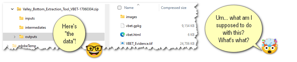
One of the most significant barriers to effective collaboration and leveraging of past work is being able to access and share any tool or model output or analysis, within the transparent context of the inputs and methods from which it was produced (Wilkinson et al. 2016). "Just send me the data", is rarely actually that simple. Plus, one of the hallmarks of scientific rigor is reproducibility.
Sharing is Expected... and Easier Today
Sharing used to be technically difficult, but today is easy. Many great tools now exist for sharing data (typically as a zip file) to comply with open access and data sharing requirements, including Zenodo, figshare, and HydroShare.
However, it can be difficult to use those platforms to make riverscapes specific data more easily consumable, explorable and useful to your audiences. Especially given the complexity of so many riverscapes tools and workflows, "can you make the data available?" is an easy thing to comply with by uploading a zip file to one of the services above, but a very difficult thing to do properly. We assert the Riverscapes community desperately needs data standards and simple tools for more effective sharing of riverscapes-specific data (Fryirs et al. 2019).
In an era of "big data", it is easy to get overwhelmed without appropriate context. Unfortunately, context means metadata, and very few researchers and practitioners have the time or are likely to produce that metadata manually. However, failure to do so contributes to "dark knowledge" (sensu Jeschke et al. 2019) through inaccessible data and information, and we can do better. We need to better leverage each other's work, but we often do not because it takes too much time.
A Better way for the Riverscapes Community
Goals
- Make it easier to produce, curate and organize riverscapes analyses in the context of the inputs and intermediates they were produced from. - i.e. make exploreable in Riverscapes Viewers
- Foster transparency, reproducibility and sharing of riverscapes data and analyses.
- Simplify ability for tool users to make tool outputs F-A-I-R or at least F-A-R.
Riverscapes Projects
Riverscapes projects can also be manually produced for any dataset and analysis to provide it context. For datasets that you want to share with a large audience, but may not produce that many times, it still may be worth the investment.
Easier to Share with Metadata
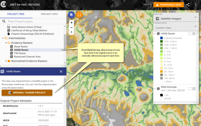
All layers have easily viewed Metadata from the Project Tree, which allows tracing back individual layers to their original sources or externally referenced projects.
Riverscapes projects can be stored in the Riverscapes Data Exchange and made publicly available. Documentation can be included at various levels:
Project level metadata
The following can be entered and edited in the Data Exchange by the project owner:
- Project summary
- Project description
- User metadata fields (if not locked*)
- Tags
Summary, description and user metadata can also be entered via the project.rs.xml file. There, a user metadata field can be designed as locked, meaning it will not be editable in the data exchange.
Moreover, Riverscapes Projects facilitate automated metadata production and housekeeping. An example of the automatically generated metadata for a production-grade, network tool is shown at left.
Scalable Analysis & Interoperability
Riverscapes projects can be accessed, modified and populated with cloud computing because querying, and batching operations are possible with a consistent data standard and storage. Plus, other riverscape-compliant projects can easily reference each other.
References
- Fryirs KA, Wheaton JM, Bizzi S, Williams R, Brierley GJ. 2019. To plug-in or not to plug-in? Geomorphic analysis of rivers using the River Styles Framework in an era of big data acquisition and automation. Wiley Interdisciplinary Reviews: Water 6 : e1372. DOI: 10.1002/wat2.1372
- Jeschke JM, Lokatis S, Bartram I, Tockner K. 2019. Knowledge in the dark: scientific challenges and ways forward. FACETS. DOI: 10.1139/facets-2019-0007
- Wilkinson MD et al. 2016. The FAIR Guiding Principles for scientific data management and stewardship. Scientific Data 3 : 160018. DOI: 10.1038/sdata.2016.18