CHaMP
The Columbia Habitat Monitoring Program (CHaMP; BPA Project No. 2011- 006-00) was designed to collect information on tributary habitat attributes that can be used to predict the freshwater productivity of anadromous salmonids reliably. The Integrated Status and Effectiveness Monitoring Program (ISEMP; BPA Project No. 2009-f) began development of the CHaMP pilot in 2010 and it was implemented in 2011. The CHaMP sampling design called for nine-years of data collection, in watersheds that represent a range of environmental conditions in the Columbia River Basin (CRB) to produce traditional and novel habitat metrics that can be “rolled-up”, that is, used to describe fish-habitat relationships relevant to three key management questions (KMQs) posed by BPA:
KMQ 1
What are the tributary habitat limiting factors or threats preventing the achievement of desired tributary habitat performance objectives?
KMQ 2
What are the relationships between tributary habitat actions and fish survival or productivity improvements, and what actions are potentially most effective? Which actions are most cost-effective to address habitat impairments?
KMQ 3
Are tributary actions achieving the expected biological and environmental improvements in habitat [and improving survival of specific fish life-stages through species growth or habitat capacity?
CHaMP was discontinued by BPA in 2017. This page describes the outcome of a renewed push to publish CHaMP data on the Riverscapes Data Exchange. While not exhaustive, those familiar will recognize many of the terms and data and find what they are looking for.
Disclaimer
The CHaMP program concluded in 2017. The data and links provided on this page were collated in 2026 as part of a preservation effort to ensure the ongoing availability of the data collected during the program.
NO WARRANTY AND LIMITATION OF LIABILITY
These data are provided "as is" and "as available" without warranty of any kind, either express or implied, including but not limited to the implied warranties of merchantability, fitness for a particular purpose, or non-infringement.
The data presented represents the state of the archive at the time of the program's termination by the Bonneville Power Administration (BPA). No additional quality control, processing, or validation has been performed on these datasets subsequent to the program's conclusion. Users should be aware that the data may contain gaps, errors, or inconsistencies inherent to large-scale monitoring initiatives.
By accessing or using these data, you acknowledge and agree that:
- The use of the data is at your sole risk.
- The providers of this data make no guarantee regarding its accuracy, completeness, or suitability for any specific analysis or purpose.
- In no event shall the providers be liable for any direct, indirect, incidental, special, exemplary, or consequential damages arising in any way out of the use of this data.
Support
Given that the CHaMP program is no longer active, there is no official support for these data. However, the following consultants continue to operate in the Pacific Northwest and can be contracted to support you within inquires or work on the data.
Acknowledgements
The work to collate and publish these CHaMP data to the Riverscapes Data Exchange was funded by NOAA and performed in 2026 by Watershed Solutions and North Arrow Research.

CHaMP was performed by a collection of consultants and agency personnel from the Pacific Northwest.


How to Find CHaMP Data
CHaMP data within the Riverscapes Data Exchange and can be found in several different ways. First, all official CHaMP data are owned by the data exchange CHaMP Organization. This link provides quick access to all CHaMP datasets.
| Organizational Concept | Tag Format | Example | Notes |
|---|---|---|---|
| Program | CHAMP_Program_Level_Outputs | CHAMP_Program_Level_Outputs | |
| Watershed | CHAMP_Watershed_XXXXXXXX | CHAMP_Watershed_John_Day | Spaces replaced with underscores. |
| Site | CHAMP_Site_XXXXXXXXXX | CHAMP_Site_YFI00001-000133 | |
| Field Season | CHAMP_Year_XXXX | CHAMP_Year_2011 | |
| Visit | CHaMP_Visit_XXXX | CHAMP_Visit_5238 | Zero padded to 4 digits |
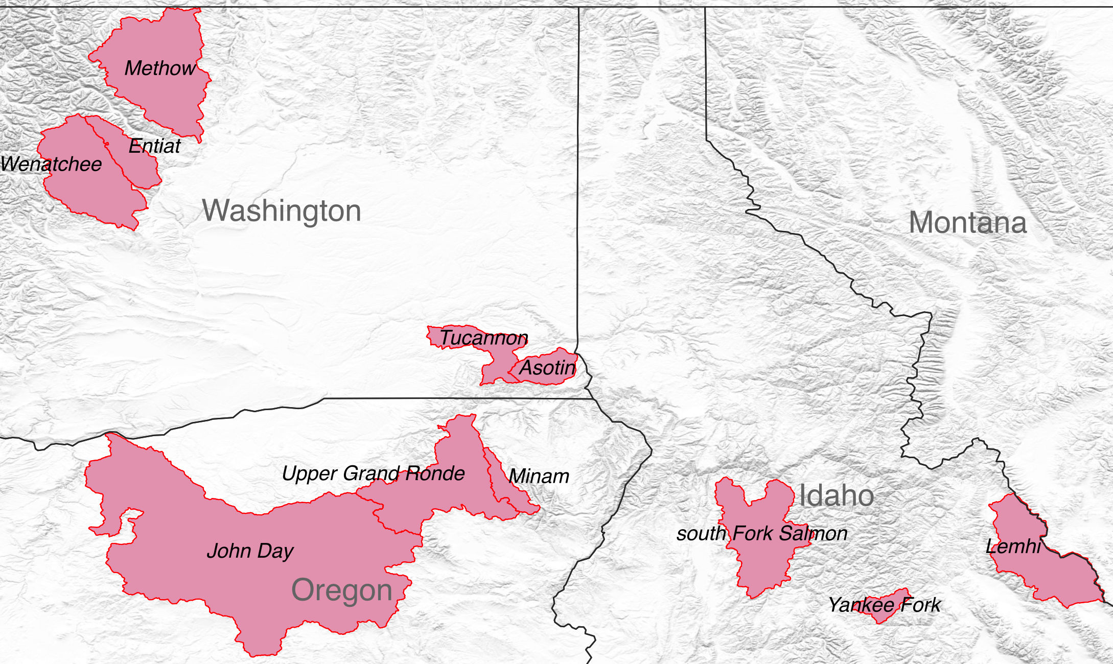
Data for individual watersheds and field seasons can be found using the table below. Click on column headers for all data associated with a particular field season. Click on row headers for all data associated with a particular watershed. Use the links inside the table for watershed and field season combinations. More focused versions of this table are available further down this page for specific types of data.
Data
CHaMP Metrics
Arguably the primary focus of CHaMP was the production of metrics in support of the key management questions above. At the conclusion of the program in 2017, CHaMP produced a final set of metrics that are available as a single CHaMP Metrics project within the Riverscapes Data Exchange. This dataset also includes a list of all watersheds, sites and visits. There is also a table defining each metric, it's units and calculation method.
Topographic and Aux Data
CHaMP collected many types of data, centered around both a high resolution topographic river survey and a series of non-spatial "auxiliary measurements". These "topo" and "aux" data have been combined into a single project for each survey and placed on the exchange.
In the table below click on the row headings to discover all projects for a particular watershed. Click on the column headings for all projects of a certain year. The cells in the table link to the specific watersheds and years. These links will take you to the Data Exchange where you can you the project data in a web map or view the metadata.
You can use the Riverscapes Commandline Interface to download the data, or you can write Python scripts to perform custom searches and batch download many projects in a single operation.
Photos
Photos were taken at the same time as the topographic surveys. The photos span a variety of purposes; some are meant to capture individual channel units, while others were associated with the survey setup (benchmarks, control points etc). The photos were taken with a variety of equipment including point-and-shoot cameras and tablets.
Stream Temperature Data
CHaMP stream temperature measurements are available as a single project for all watersheds, sites and years. The project contains both a SQLite and Microsoft Access copy of the data.
Kris McNyset developed stream temperature predictions for portions of the Columbia River Basin. These data are available by prediction type:
- Potential Maximum Temperature
- Potential Mean Temperature
- Potential Minimum Temperature
- Max Temperature
- Mean Temperature
Macroinvertebrates
CHaMP macroinvertebrate data were provided by NOAA and uploaded into the Data Exchange here:
Hydraulic Modeling
Matt Nahorniak, with South Fork Research, developed a semi-automated workflow for running the Delft3D hydraulic model on the CHaMP high resolution topographic data. The models were run at both observed and simulated discharges for a subset of the CHaMP surveys. 369 Hydraulic Model projects are in the Riverscapes Data Exchange. Each project represents one CHaMP survey modelled at one or more discharges.
Fish Habitat Modelling
CHaMP funded the development of a fish habitat model that used both habitat suitability curves and a fuzzy inference system (FIS) to estimate fish habitat. These models were run at various flow stages and salmonid life stages. 51 fish habitat model projects are available in the Riverscapes Data Exchange.
CAD Export
Towards the end of CHaMP, the topographic survey data were requested in CAD format by BPA. This bulk export is available in the Data Exchange as 2,735 CAD Export projects.
Predicted Conductivity
There are 3 predicted electric conductivity projects developed by Jesse Langdon at South Fork Research. These extrapolated CHaMP survey conductivity measurements for the purpose of validating the gross primary productivity (GPP) modeling efforts within CHaMP. See the Conductivity Tools code on GitHub.
Riparian Condition Assessment (RCA)
The Ecogeomorphology and Topographic Analysis laboratory (ETAL; now called USU Riverscapes Assessment Monitoring Lab - RAM) at Utah State University produced 11 Riparian Condition Assessment projects for various parts of the Columbia River Basin. The RCA model has continued to evolve and is now called The River Condition Assessment Tool (RCAT). In 2025, the Riverscapes Consortium has run RCAT for over 99% of the conterminous United States, the outputs of which are available in the Data Exchange as over 14,000 RCAT projects.
Riparian Vegetation Departure (RVD)
The ETAL also ran the Riparian Vegetation Departure for the same locations where they ran RCA. This produced 23 RVD projects. RVD has since been incorporated into RCAT and is available as part of the aforementioned 2025 CONUS effort.
Solar
25 CHaMP solar modelling projects are available in the Data Exchange. The Solar Stream Tools model, leveraging CHaMP Suneye measurements, was developed by South Fork Research.
QRF
A single project contains the final QRF analysis produced by CHaMP. These data were obtained from C. Volk CHaMP files archive provided to North Arrow Research and placed on Amazon S3.
Kevin E., Michael W. Ackerman, Richard A. Carmichael, Sarah Hoffman, and Chris Beasley (2021). Estimating Carrying Capacity for Juvenile Salmon using Quantile Random Forest Models. Ecosphere http://doi.org/10.1002/ecs2.3404
GRTS Master Sample
CHaMP sites were selected from a master sample generated using the Environmental Protection Agency (EPA) Generalized Random Tessellation Stratified (GTRS) process. Master samples are available in the Data Exchange for each of the US States in which CHaMP was performed.
Documents
- CHaMP Study Design
- Columbia Basin Master Sample Documentation
- CHaMP Final Report
- Scouting Protocol
- Protocol
- Total Station Manuals
- Topo Processing Workflow
Software and Code
The following software tools and code were either used by CHaMP or developed by the program. While several have now been deprecated, some have continued to be developed and evolved into production grade tools.
Riverscapes Data Exchange
The data exchange is the latest iteration of a warehouse that was built to host CHaMP data for running metrics.
BRAT
The Beaver Restoration Assessment Toolbox was first being developed around the same time as CHaMP.
RCAT
The Riparian Corridor Assessment Tool grew out of the RCA and RVD tools development during CHaMP.
GCD
Geomorphic Change Detection was performed on CHaMP topographic surveys to measure change between surveys.
Riverscapes Studio (QRiS)
QRiS is the latest product focused on processing project scale geospatial data, related to the CHaMP Topo Toolbar that was used to process high resolution topographic surveys.
VBET
The Valley Bottom Extraction Tool (VBET) was developed by Joe Wheaton and Jordan Gilbert during the CHaMP program.
Deprecated Software
CHaMP Metrics
The final version of the code that calculates topo, aux and topo+aux metrics. This code was migrated from South Fork Research and turned into a Riverscapes Tool.
CHaMP Transformation Toolkit
The CTT was developed by Joe Wheaton and Chris Gerrard at USU to apply coordinate transformations to CHaMP topographic surveys.
Solar Stream Tool
Gross Primary Productivity toolkit developed by South Fork Research under CHaMP and ISEMP.
Tributary Impact Tool
The Tributary Impact Tool which finds intersections in a stream network and calculates the percent chance of the tributary creating a large fan in the mainstem.
PNET
Point Network Extraction Tool
GUT
Geomorphic Unit Tool developed by Joe Wheaton and Sara Bangen at Utah State University.
Conductivity Tools
CHaMP Workbench
Desktop software for housekeeping tasks such as viewing CHaMP metrics and running miscellaneous tasks.
Fish Habitat Model
Desktop software, written in C# for running fish habitat models.
PyGNAT
Geomorphic Network Attribute Tool.
Hydraulic Modelling
R Code to parameterize and orchestrate running the Delft3D hydraulic model.
Stream Temperature Modelling
R Code for modelling stream temperature predictions.
Status and Trend Rollups
Provide design based status and trend estimates for CHaMP metrics, by watershed and (opionally) other subgroups. Estimate the components of variance for CHaMP metrics, including measurement noise.
Bioenergetics Model
Lifecycle Modelling
NREI
Net Rate of Energy Intake model developed by Eric Wall and Nick Bouwes.